Tamborine Rainforest Skywalk is located close to Bearded Dragon Hotel Accommodation. Just under 9km from our venue you can find this great Tamborine Attraction on Tamborine Mountain Road as you head up the mountain.
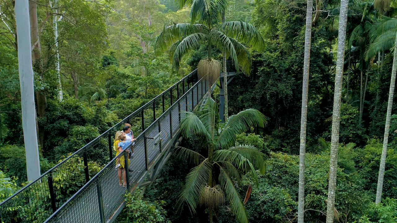
Tamborine Rainforest Skywalk located on the way up Tamborine Mountain from the is an innovative way to view this spectacular environment. Visitors depart from the Eco Info Gallery, which offers comprehensive local flora and fauna interpretive panels & displays and a fresh water aquarium, to begin an adventure on a spectacular elevated walkway, high above the ground in the beautiful rainforest canopy.
Descending gradually to the densely vegetated rainforest floor beside the creek, the walk follows points of interest including rock pools, a butterfly lookout, local history enclosure plus sheltered rest areas along the way until reaching the amazing Cantilever.
Visitors return to the Centre which has a great coffee and gift shop with quality Tamborine Mountain merchandise, toilet facilities (including accessible facilities), and bus/car parking areas. The skywalk takes approximately 50 minutes and is suitable for all ages.
The Skywalk is open 7 days from 9:30am with final walks at 4pm (closing at 5pm) and entry prices are Adults $19.50, Children $9.50, Family $44.00 (2 adults & 1 children), Extra Child $5.00 and Senior/Student Card Holders $16.50.
Coach and visitor parking on site. Toilets including disabled are available. Contact the Bearded Dragon if you would like to do a package tour with lunch and other activities for your group. Why not stay in accommodation close by to the Skywalk.
The Skywalk is the brainchild of the Moore family, who began building on their property high in the Tamborine Mountain rainforest in 2004. It’s a 1.5km walk on elevated steel walkways, suspended high above the rainforest floor and held up by slightly-wobbly-but-firmly-rooted poles.
The creation of the Skywalk was not easy, as the Moores could not just plop poles in the ground wherever they wanted the fact that they are nestled in amongst national parks made sure of that. As a result, it seems like there are all too few poles to hold the whole structure up, but at the same time, you know you are visiting a place where great pains have been taken to keep nature as is while still making it accessible to those that may not be serious bushwalkers otherwise.
The Best way to get to the Tamborine Rainforest Skywalk and Tamborine Mountain.
From Brisbane:
Follow the M1 Pacific Motorway south past Logan, Yatala & Beenleigh, and take the Oxenford exit (no. 57) which is the next exit past Dreamworld. This will take you over the motorway, and bring you up Tamborine-Oxenford Road (see Gold Coast Directions).
OR:
Follow the Pacific Highway until you reach the City Road, Beenleigh exit. Follow the signs to Tamborine Mountain which will lead you to Tamborine Village where you will find the Bearded Dragon Hotel at the base of Tamborine Mountain. Keep the Bearded Dragon on your left side, and follow Tamborine Mountain Road to the top of the mountain. This road will take you past Thunderbird Park and the Rainforest Skywalk � the next road on your right side will take you towards Gallery Walk, otherwise, if you keep following the road, it will bring you into North Tamborine where you will find the Tamborine Mountain Information Centre, Shell service station, shops, cafes and further out, wineries and more.
From Western Suburbs of Brisbane:
If traveling from Yarrabilba, Logan Village, Logan, Ipswich, Loganlea, Browns Plains or the likes, take Waterford Tamborine Road or travel along the Mount Lindsey Highway to Camp Cable Road and then onto Tamborine Village. You will find the Bearded Dragon at the base of Tamborine Mountain keep the Bearded Dragon on your left side, and follow Tamborine Mountain Road to the top of the mountain. This road will take you past Thunderbird Park and the Rainforest Skywalk the next road on your right side will take you towards Gallery Walk, otherwise, if you keep following the road, it will bring you into North Tamborine where you will find the Tamborine Mountain Information Centre, Shell service station, shops, cafes and further out, wineries and more.
This exciting new Eco-Adventure offers guests a unique and thrilling way to explore the beautiful rainforest canopies. Set in a magical 30 acres of privately owned rainforest beside the crystal clear rock-pools of Cedar Creek on Mt Tamborine, Queensland, Australia.
The walk departs directly from the Eco Gallery with a comprehensive array of Australian rainforest flora and fauna displays.
The walk takes approximately 45-55 minutes at a leisurely pace, when pausing to view the many points of interest and information along the way.
The entire walk totals 1.5 kms and is a combination of forest floor trails, 300 metres of high-tech steel bridges through the highest points of the upper canopy, and a 40 metre cantilever bridge that soars a breathtaking 30 metres above the creek and rainforest below.
Obviously there are some mixed reviews on the Tamborine Skywalk Attraction with many bushwalkers and day visitors to Tamborine preferring to utilise the many FREE bushwalks and scenic views that are on Tamborine Mountain and all around the Scenic Rim. We still highly recommend the Skywalk Centre and Treetop canopy as nothing gets you such a great feeling of being in the canopy itself. Awesome photo opportunities of the rainforest and beyond and the unique experience that sometimes is not easy to put a price on.
Visit the Rainforest Skywalk attraction for yourself and decide and make sure you call into the Bearded Dragon Hotel at Tamborine for some great craft beers and awesome burgers and steaks served all day everyday!
If you prefer the FREE bushwalking activities that Tamborine Mountain and Scenic Rim have to offer then here is a very good list of the TOP 30 spots in the Scenic Rim National Park. Formerly known as the Beaudesert Shire now with a name that really encompasses the scenic beauty that is so close to Gold Coast , Ipswich, Logan and Brisbane for a great day out bushwalking , taking scenic photographs and generally exploring all the great wineries, craft breweries and awesome pubs that the region has to offer.
Top 30 Scenic Rim National Park Walks
1.Lower Portals Track Mt Barney National Park (7.4km/3 hours)
This track leaves from the Lower Portals car park and goes to the Lower Portals, a beautiful pool along a gorge on Mount Barney Creek.This walk has moderate to steep gradients. A parking area and toilets are available.
2. Cronan Creek Track Mt Barney National Park (13km 5 hours)
From Yellow Pinch car park, a pleasant walk along the fire trail leads you past the base of South Ridge into cool green rainforest. (Note: The climb up South Ridge is rugged and steep and for experienced bush walkers only). Parking, picnic area, cooking area and toilets are available.
3. Mee-bor-rum Circuit Moogerah Peaks National Park Mt French section (720m/15 mins)
Circuit track passes through heathland and features the East cliff lookout with views of Tamborine, Lamington and Mount Barney. Care mustbe taken at the lookout as it is a natural feature and has no handrails. Further alongthe track a circular platform with seating provides views of the heathland and southern section of Mount French.
Wheelchair access on this track is only possible tothe heathland beyond here the track is rough and uneven. Parking area, BBQ (wood), picnic area, toilets, natural lookout, campground area and water is available.
4. Mt Edwards Summit Moogerah Peaks National Park Mt Edwards section (6km/3.5 hours)
Mount Edwards is accessible from the Moogerah Dam picnic area at the end of Moogerah Connection Road. From the picnic area walk across the Moogerah Dam wall to the park entrance. This walk is suitable for experienced bush walkers only and requires a reasonable level of fitness. There are no formed tracks, signs or facilities so you must be self-reliant. Warning! There are sheer cliffs and slippery rocks particularly after rainfall.
One slip could be fatal serious injury or death mayresult from walking near the cliff edge. Keep to the track supervise children closely.
5. Cotswold Track Mt Barney National Park Mount Maroon summit (6km/8 hours)
In spring this summit provides spectacular wildflower displays set against the craggy peaks of the Scenic Rim. Allow a full day to reach the summit safely and to return to your vehicle.
Parking area and toilets are available.
6.North Cliff Track Moogerah Peaks National Park Mt French section (720m/15 mins)
This track leads to Logans lookout with excellent, panoramic views over the Fassifern Valley, with the Main Range escarpment to the west and Flinders Peak and beyond to
the east. North Cliff track is suitable for wheelchairs with assistance. Parking area, BBQ (wood), picnic area, toilets, natural lookout, campground area and water is available.
7. Rainforest Circuit Main Range National Park Cunninghams Gap (1.6km/30 mins)
The circuit commences at the eastern end of the crest carpark. It passes the Allan Cunningham monument, and is the beginning of an extensive bush track system on the northern side of the Gap. The Fassifern Valley lookout track forms the eastern part of the circuit. Turn left at the base of the stairs totake the easiest way around the circuit. Parking area and toilets available.
8. Fassifern Valley Lookout Main Range National Park (1.2km/20 mins)
Commencing at the crest carpark, the Fassifern Valley lookout provides a spectacular view over the Moogerah Peaks, Fassifern Valley and Lake Moogerah. The track commences at the eastern end of the crest carpark a
nd forms the eastern part of the Rainforest circuit. Parking area, toilets, constructed lookout available.
9. Mount Cordeaux Track Main Range National Park Cunninghams Gap (6.8km/2.5 hours)
Mount Cordeaux (1135 m) is known to Aboriginal people as Niamboyoo. Branching off the Rainforest Circuit, the track zigzags through rainforest to the exposed upper slopes, ending at a lookout on the southern side. The cliffface of Mount Cordeaux is spectacular in spring and early summer when the giant spear lilies (Doryanthes palmeri) are in flower. Take care at the cliff edge. Parking area and toilets are available.
10. Mount Mitchell Track Main Range National Park Cunninghams Gap (10.2km/3 hours)
A graded walking track to the twin peaks of Mount Mitchell begins on the southern side of the highway. Take care when crossing the highway. Rainforest and open eucalypt forest will be encountered on this track, which ends on a knife-edge ridge above a sheer cliff on the east peak of Mount Mitchell (1168 m). This peak is known as Cooyinnirra to the Aboriginal people. Take care at the cliff edge.Parking area and toilets available.
11. Heritage Trail Main Range National Park Spicers Gap (3.2km/1 hour)
From the Governors Chair carpark, an interesting self-guiding walk, showing various road construction methods,follows the historic road. Parking area is available.
12.Sylvesters Lookout Main Range National Park Goomburra (940m/30 mins)
Sylvesters lookout offers magnificent views over the coastal plains below including the southern tip of Lake Moogerah and the rugged borderranges to the south. The track starts from Lookout Road a 4.7 km drive from the Kurrajong picnic spot. This road is a dry weather road only and is closed by a locked gate near Kurrajong picnic area during wet weather.
13. Palm Grove Circuit Tamborine National Park Palm Grove section (2.6km/1 hour)
View palm groves and stunning Tamborine rainforest with emergent strangler figs and distinctively-buttressed yellow carabeens feature on this walk. There are three different ways of accessing this bush walking area of Tambroine for a map and directions to the local Tamborine Bush walks and walking trails http://www.discovertamborine.com.au/index.php/the-palm-grove-section-of-the-tamborine-national-park/
14. Curtis Falls Track Tamborine National Park Joalah section (1.1kn/30 mins)
A stunningly enchanting walk begins in wet eucalypt forest beneath towering flooded gums of Tamborine. Notice a slight drop in temperature as the wet eucalypt forest merges into lush rainforest.
Beautiful crows nest and staghorn ferns can be seenin the canopy above. Great bushwalking train no matter the weather on Tamborine and particularly stunning after rain.
15. Sandy Creek Circuit Tamborine National Park Knoll section (2.6km/1 hour) This walk features lush rainforest with towering trees emerging through the canopy. A 100 m track branches off through open eucalypt forest to Cameron Falls lookout. On a clear day enjoy views across the valley to Mount Flinders and southern suburbs of Brisbane. This bush track travels close to steep cliff edges. Please remain on the designated
track, stay behind fences and supervise children atall times.
16. Witches Falls Circuit Tamborine National Park Witches Falls section (3.1km/1 hour)
Witches Falls circuit starts just beyond the commemorative shelter. The track zigzags down the mountain side through an open forest of banksia trees and into rainforest with giant strangler figs. This circuit passes seasonal lagoons surrounded by piabeen palm groves before reaching Witches Falls. After heavy rain the lagoons fill with water and spring to life with a variety of insect and frog species. An alternative access track can be used in this section during wet conditions. The waterfall only flows after recent rain and is best viewed from the lookout platform, accessed via a
200 m detour from the main circuit.
17. Caves Circuit Lamington National Park Binna Burra section (5km/1.5 hours)
From the parks information centre, this interesting track winds up through open forest and rainforest to emerge on the road near the BinnaBurra Mountain Lodge road entrance. Alternatively, begin this track from the Binna Burra Mountain Lodge road entrance and return via Binna Burra Road. Caution: this track contains unstable surfaces. Rockfalls may occur on the track and in Kweebani Cave. For your safety, avoid lingering near the cave – move along the track and view the cave from a safe distance. The track provides excellent views into the Coomera Valley and passes a large red cedar and fine specimens of other rainforest tree species. The major cliff line opposite is of a flow of rhyolite and deposits of boulders and ash (tuff) can be seen in overhanging caves. Possibly the largest intact stand of hoop pine (Araucaria cunninghamii) can be seen
along the Darlington Range.
White-throated treecreepers, members of one of the oldest groups of songbirds, are frequently seen on this track. Koalas are often seen in open forest areas along the walk. Take care when walking down the bitumen road to return to the start of the circuit, especially on weekends when traffic is heavy. A self-guiding brochure produced by the Lamington Natural History Association for this circuit is available at the national parks information centre, kiosk and Binna Burra Mountain Lodge.
18. Bellbird Lookout Track Lamington National Park Binna Burra section (2km/1hour)
This track branches off the Ships Stern circuit anddescends through rainforest and open forest before emerging suddenly at Bellbird lookout. This natural lookout that has no handrails and is above a very high, steep cliff (this lookout and most of the track is on Binna Burra Lodge land and is not part of the national park). Please keep children under close supervision and keep well away from the cliffedge. From here you get an excellent view of Ships Stern, Turtle Rock, Egg Rock (Kurraragin) and Numinbah Valley. This is a brilliant opportunity to view what millions of years of erosion, landslides and weathering have created. These continuing geological processes will continue to shape what you see before you. Hoop pines (Araucaria cun ninghamii) can be seen from the lookout, growing on the exposed northern slopes. Harvesting of hoop pine and red cedar (Toona ciliata) led to the initial European settlement and ultimate clearing of Numinbah Valley for agriculture.
19. Ships Stern Circuit part of the Gold Coast Hinterland Great Walk Lamington National Park Binna Burra section (21km/8 hours) emphasise Lower Ballanjui Falls see Binna Burra Mountain Lodge website http://www.binnaburralodge.com.au/Binna-Burra/Exploring-Binna-Burra/Walking-at-Binna-Burra/Lamington-National-Park Ships Stern circuit starts 300m back from the road end (opposite the road entrance to Binna Burra Mountain Lodge). It descends into Kurraragin Valley (Nixon Creek) where you will see fine stands of plabeen palm (Archontophoenixcunninghamii), large red cedar (Toona ciliata), and majestic flooded gum (Eucalyptus grandis). Lower Ballunjui Falls, 5.3km from the track entrance, is reached by a short side-track that branches off the main track. On theShips Stern Range, which is formed of rhyolite, the rainforest gives way to eucalypt forest with a dense understorey of spring-blooming wildflowers. Lookouts provide viewsinto Numinbah and Kurraragin valleys, giving us a glimpse of a stage in the continuing erosion of the Tweed Shield Volcano. The unmistakable Egg Rock is a rhyolite plug that formed in one of the subsidiary vents of this once massive shield volcano. The track continues through rainforest and open forest with another side-track(1.3km one way) providing access to the top of Ballunjui Falls before joining the Border Track to return to Binna Burra. This track forms part of the Gold Coast Hinterland Great Walk, arrow markers indicate the route. Please do not attempt this walk unless you are a Great Walker and have a copy of the Gold Coast Hinterland Great Walk Topographic Map.
20. Tree Top Walkway OReillys Rainforest Retreat (1.5km/30 mins)
Booyong Boardwalk, featuring some excellent interpretive signage, leads you from the front of OReillys Rainforest Retreat to the walkway, which is a series of suspension bridges that take you 16m up into the rainforest canopy. The adventurous can climb ladders to a crows nest like platform in a fig tree 30m above the ground. Not recommended for those who suffer from a fear of heights.
21.Orchid Circuit see OReillys website http://www.oreillys.com.au/lamington- national-park/bushwalking/half-day-walks/
22.Wishing Tree & Micks Tower
see OReillys website http://www.oreillys.com.au/lamington-national-park/bushwalking/half-day-walks/
23. Python Rock Track Lamington National Park GreenMountains section (3.4km/1 hour)
This walking track leaves the Lamington National Park Road 800m downhill from the national parks information centre. Some parking is available at the walking track entrance. Python Rock lookout (1.6km from the tracks entrance) providesviews of Morans Falls, Castle Crag and Lost World. Views from the lookout highlight the geological processes of erosion, including valley widening and escarpment formation. This amzing walking track passes through a closed rainforest community into an open eucalypt forest where fire-adapted species such as grasstrees, hakeas and various wildflowers grow. The guttural popping of the masked mountain frog (Kyarranus loveridgei) can be heard on wet or moist days in late spring and summer. These ancient frogs are members of the Gondwanan family commonly known as southern frogs. A great treat for any bush walker of all age in the scenic rim. A world away from the town of Beaudesert where you can escape to the true nature at the heart of scenic rim shire.
24. West Cliff (Pats Bluff)
see OReillys websitehttp://www.oreillys.com.au/lamington-national-park/bushwalking/half-day-walks/
25. Morans Falls Lamington National Park Green Mountains section (4.6km/1.5 hours)
This track leaves the Lamington National Park Road 800m downhill from the national parks information centre. Limited parking is available at the track entrance. An excellent view of Morans Falls and Morans Creek gorge can be seen from the constructed lookout located before the creek crossing. Layers of ancient volcanic lava flows are also visible;
the more resistant have formed small cliff-lines along the valley, and is best seen at the second lookout located at the end of the track. Please keep to the track as short cuts create erosion. Please keep the scenic rim special and all walkers should take care for our fragile environment on all the walking tracks and beyond.
26. Picnic Rock and Elabana Falls
see OReillys website http://www.oreillys.com.au/lamington-national-park/bushwalking/half-day-walks/
27. Box Forest Circuit Lamington National Park Green Mountains section (10.9km/4 hours)
This track branches from the Border Track 1.8km from the track entrance and leads directly to Picnic Rock and Elabana Falls. It runs through rainforest and past impressive stands of smooth, pink-barked brush box (Lophostemon confertus) before reaching the falls. Similar brush box in other parts of the World Heritage area have been radiocarbon
dated at 1500 years, making these giant trees the oldest ever carbon-dated on Australias mainland. If you intend walking this entire circuit, walk in a clockwise direction and exit via Elabana Falls and Picnic Rock.
28. Tullawallal Circuit Lamington National Park Binna Burra section (5km/1.5hours) Visit the most accessible cool temperate rainforestin Lamington and the closest patch of this forest type to Binna Burra. At the trailhead take the right branch of the Rainforest circuit and follow signs to the Tullawallal circuit. The pocket of Antarctic beech (Nothofagus moorei) on the summit is the northernmost location of this species in
Australia. These trees are one of our remaining links with the ancient forests of Gondwana. Nothofagus forests were once widespread across the continent and provided a habitat for many animals that have long since disappeared from our landscape. From Tullawallal, return to the track junction, turn left. At the second junction turn left
onto the Border Track and continue to the Binna Burra carpark.
29. Rainforest Circuit Lamington National Park Binna Burra section (1.2km/30mins)
For a quick introduction to the typical warm subtropical rainforest of Lamington, follow the Border Track for 500m, then branch rightand return to the picnic area along the rainforest circuit track. Bowerbirds and catbirds are commonly heard. A self-guiding brochure produced by the Lamington Natural History Association (LNHA Inc.) is available at the national park information centre, campgroundkiosk and Binna Burra Mountain
Lodge.
30. Lower Bellbird Circuit Lamington National Park Binna Burra section (12km/4 hours)
This track branches off the Ships Stern circuit 3.7km from the track entrance. The track passes through a patch of dry rainforest, regarded as an example of the rise of the dry adapted flora now widespread in Australia. Follow the track below Bellbird lookout and emerge at a clearing, once a dairy farm. The circuit returns via the Binna Burra Road. Please note that choosing to return via the Caves track adds 1.6km to the walk. This track forms part of the Gold Coast Hinterland Great Walk, arrow markers indicate the route. Please do not attempt this walk unless you are a Great Walker and have a copy of the Gold Coast Hinterland Great Walk Topographic Map.
So if you are looking for walking tracks close to Brisbane, walking tracks close to Gold coast or the Bushwalk close to Logan or Ipswich then you will enjoy the scenic rim and a special visit to Tamborine you will find the Bearded Dragon ready to serve you a cold drink and great meal all day every day.
Big thankyou to Scenic Rim Council and Tamborine Mountain Chamber of Commerce and Tamborine Rainforest Skywalk for the information provided in this article.